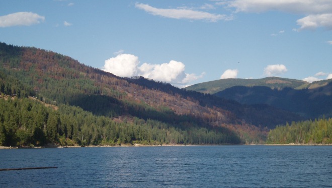
Pend d'Oreille Recreation Area

Reservoir doubles as a power source, recreation destination
Our Pend d'Oreille Reservoir serves not only as a source of hydroelectric power, but also as an attractive recreation area for the public.
Recreational opportunities include camping, picnicking, swimming, boating, canoeing, wildlife viewing and fishing.
Pend d'Oreille is located in the unceded traditional territories of the syilx Okanagan, Secwepemc, and Ktunaxa Nations.
Where it is and what to do there
The Pend d'Oreille River starts in Idaho and weaves through northeast Washington State before entering Canada, where it flows through the Seven Mile Dam and then into the Columbia River, southeast of Trail. The B.C. section features the 22-site Buckley campground.
Recreational opportunities on the B.C. section of the Pend d'Oreille River include camping, picnicking, swimming, boating, canoeing, wildlife viewing, and fishing.
Buckley campground
Normally open from mid-May to September 30, the campground features
- Designated wheelchair accessible campsites and pit toilets
- 22 campsites, each with a fire ring and picnic table
- Maximum 14 overnight visits per season.
- No reservation of sites is permitted. Campers failing to occupy sites overnight may have their equipment removed at their expense so that others may use the site.
- Sandy beach
- Four pit toilets, firewood (for a small fee, cash only), drinking water, one hand-pump water well
- Boat launch (gravel) with a parking lot and day-use areas
- 60 metres of boarding floats
Seven Mile Dam viewpoints
Open year-round, the viewpoint areas feature:
- Two picnic tables
- Two-vehicle pull-outs
- Two information shelters
Safety & other key visitor info
Reservoir levels can change rapidly (up to 6 metres each day and can expose shoals or anchored debris. In addition, spring runoff will often result in inflows containing debris. Boaters must be particularly vigilant during these periods.
- Avoid the designated hazard areas above and below Seven Mile Dam and obey all posted signs.
- Always remain upstream of the debris boom on the Seven Mile Reservoir.
- Obey all boater safety regulations.
- Ensure that you have an accurate map.
- Carry emergency and safety equipment, extra shear pins and propeller.
- Ensure familiarity with local conditions and reservoir hazards.
- Inform others of your destination and when you plan to return.
Check the weather forecast.
- Keep fires contained to fire rings.
- Firearms and hunting are prohibited within the BC Hydro Recreation Area.
- Deposit all refuse in the containers provided.
- Camping can bring you into contact with many species of wildlife, including deer, bears and cougars. Never feed wildlife and keep your pets under control. Dogs must be on a leash at all times. Ensure that all food materials, garbage and fish entrails are bagged securely and placed in the appropriate containers.
- Please be respectful of fellow campers and obey instructions from the facility operator or campground host.
- Watch for work vehicles and heavy equipment within the vicinity of the dam.
History and hydroelectric operation
People of the Kalispel First Nation were the first to live in the Pend d'Oreille Valley, thriving on the area's abundant flora and fauna.
The valley's name – literally "earring" – was coined by French-Canadian voyageurs in reference to the local native people who made a practice of wearing dangling shell earrings.
In 1855 gold was discovered where the Pend d'Oreille River joins the Columbia River. The Dewdney Trail, stretching from Fort Hope to the gold fields near Fort Steele in the East Kootenays, opened this area up to mineral exploration, the development of mines, and later, to logging and hydroelectric power generation.
Reservoir was formed in 1979
Clearing for Pend d'Oreille Reservoir started in the fall of 1976. The entire reservoir was cleared prior to flooding to its initial level of 522.7 metres (1,715 feet). Flooding took place in November 1979. Further clearing was carried out in 1988 when the reservoir's maximum operating elevation was increased to 527.3 m.
A number of privately owned parcels of land were acquired by BC Hydro for the project. In all, 335 ha (835 acres) were transferred from BC Hydro to the BC Ministry of Environment to be managed for white-tailed deer habitat.
Dam gets the most out of the reservoir
The Seven Mile project has the highest power yield per acre flooded of any operational hydroelectric plant in B.C.
Power development consists of a concrete gravity dam, spillway, powerhouse, switch-yard, system of access roads and other associated works. The dam is about 65 m (215 feet) high, with a crest length of 350 m (1,140 feet). The powerhouse has four generating units, with the last installed in 2003.
The total generating capacity is 790,000 kW. The reservoir behind the dam extends some 15km (9 miles) upstream across the American border to the toe of the Boundary Dam. The reservoir is about 420 ha (1,040 acres) in area, which includes 170 ha (425 acres) of flooded river channel. Normal maximum reservoir level is 527.3 m (1,730 feet) elevation.